Experience the brilliance of GeoFM™ Data Sources — an AI-driven, multi-layered ecosystem that powers modern Utility GIS. Explore its intelligent ETL (Export, Transform, Load) process, digitization, BIM integration, and planning features designed for precision, scalability, and innovation.
GeoFM™ Data Sources – Redefining the Future of Geospatial Intelligence
Every great technology begins with a strong foundation — and for GeoFM™, that foundation is its Data Sources.
This isn’t just another data pipeline; it’s a living digital ecosystem where intelligence, precision, and automation converge.
At GeoFM™, we believe that data is not just collected; it is cultivated.
Our Data Sources framework empowers organizations to unlock the true value of their spatial data — seamlessly integrating design intelligence, field precision, and cloud scalability into one powerful, AI-enabled Utility GIS platform.
The Power of GeoFM™ Data Sources
GeoFM™ Data Sources form the core operational layer of our Unified Utility GIS System, serving as the bridge between ground realities and digital intelligence.
Each component — from Sourcing to BIM/Revit — is a specialized module working in harmony to ensure data accuracy, consistency, and usability across every stage of infrastructure management.
Core Components of the GeoFM™ Data Sources
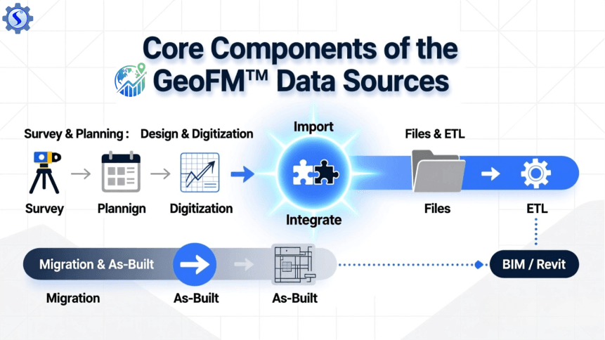
1. Sourcing – The First Step Toward Digital Precision
GeoFM™ starts where real intelligence begins: Sourcing.
Our sourcing module gathers authentic, high-quality geospatial data from multiple origins — whether from field surveys, satellite imagery, or engineering archives.
It ensures every project begins with data that’s reliable, detailed, and geo-referenced to perfection.
GeoFM™ Data Sources form the core operational layer of our Unified Utility GIS System, serving as the bridge between ground realities and digital intelligence.
Each component — from Sourcing to BIM/Revit — is a specialized module working in harmony to ensure data accuracy, consistency, and usability across every stage of infrastructure management.
2. Survey – Capturing Reality with Unmatched Accuracy
Our Survey layer brings the physical world into the digital realm.
Using cutting-edge technologies like GNSS, GeoFM™ ensures that every inch of the mapped environment is recorded with the utmost precision.
This real-world accuracy becomes the foundation for smart planning, design, and maintenance of utility networks.
3. Import – Bridging Data from Everywhere
Data comes in many formats — and GeoFM™ speaks to them all.
From legacy GIS files to modern BIM models, the Import engine allows users to bring data from any source into the GeoFM™ environment.
Its adaptive file recognition automatically reads formats like DWG, SHP, DXF, and Revit, making data import as smooth as it is secure.
4. Integrate – Merging Intelligence into One Framework
Integration is where GeoFM™ truly shines.
Through our Integrate module, multiple data sources converge into a unified geospatial ecosystem.
This fusion of design, survey, and asset data creates a single, harmonized digital environment that supports real-time visualization, collaboration, and management.
5. Design – Transforming Ideas into Digital Networks
Design is not just drawing lines — it’s creating intelligence.
GeoFM™ allows engineers and planners to design smart utility networks, leveraging GIS precision and engineering standards.
Every design element is embedded with metadata, ready for downstream use in construction, maintenance, and digital twins.
6. Files – Organized, Secure, Accessible
Our Files module serves as a secure repository for every data asset within GeoFM™.
From CAD drawings and imagery to reports and plans, all files are indexed, geo-tagged, and instantly retrievable — enabling smooth collaboration and reliable documentation.
7. Digitization – From Paper to Digital Power
With GeoFM™, manual records become digital intelligence.
Our Digitization process transforms paper-based maps, field notes, and archives into GIS-ready digital assets.
The result is clean, accurate, and fully interactive data that’s instantly integrated into the utility’s spatial database.
8. ETL (Export, Transform, Load) – The Heart of GeoFM™ Data Intelligence
The ETL engine is the beating heart of the GeoFM™ Data Sources architecture.
Export:
GeoFM™ extracts data from diverse origins — including field devices, BIM models, CAD files — while retaining spatial integrity and metadata.
Transform:
This is where the magic happens.
GeoFM™’s AI-powered transformation logic cleans, validates, and enriches data. It aligns coordinate systems, merges attributes, and ensures schema consistency.
Errors are corrected automatically, and datasets are standardized for GIS deployment.
Load:
Finally, refined data is seamlessly loaded into GeoFM’s SaaS ecosystem — including GIS Web Maps, Engineering BIM SaaS, and AI-based analytics layers.
Once loaded, it becomes live, searchable, and ready for dashboards, mobile apps, and enterprise analytics.
The ETL process ensures that every dataset within GeoFM™ is accurate, optimized, and ready for intelligent decision-making.
9. Migration – Evolving with Data Continuity
Change is constant — and GeoFM™ ensures continuity through intelligent data migration.
Whether transitioning from old systems or updating to new digital standards, the migration layer preserves data structure, georeferencing, and historical integrity without compromise.
10. Planning – Empowering Strategic Foresight
GeoFM™ transforms raw data into actionable foresight.
Through our Planning layer, utilities can analyze demand, optimize networks, and forecast growth.
It’s not just data visualization — it’s data-driven strategy powered by precision and AI.
11. As-Built – Reflecting the Real World
Every completed network deserves an accurate digital reflection.
The As-Built process in GeoFM™ captures the final, verified state of constructed assets.
It ensures that operational maps, inspection systems, and maintenance databases always match real-world infrastructure.
12. BIM / Revit – The Bridge Between Design and Reality
At GeoFM™, BIM and Revit integration connect the precision of building models with the spatial intelligence of GIS.
This synergy produces 3D digital twins — interactive, intelligent models that visualize every component of utility infrastructure, from underground cables to overhead networks.
Why GeoFM™ Data Sources Matter
GeoFM™ Data Sources are not just tools — they are the lifeblood of a modern digital utility network.
They bring clarity to complexity, turning fragmented information into coordinated intelligence.
Every feature is designed to enhance performance, ensure data accuracy, and empower decision-makers with the information they need to act confidently.
Built for the Future – Scalable, Secure, and Intelligent
GeoFM™ Data Sources are designed with scalability and resilience in mind.
- Cloud-ready infrastructure ensures accessibility and performance.
- AI automation eliminates manual errors.
- Data governance and standardization maintain consistency across projects.
- Secure protocols protect every layer of information.
From small municipalities to nationwide utility networks, GeoFM™ scales effortlessly — delivering unmatched reliability and precision.
GeoFM™ – Where Data Becomes Intelligence
At GeoFM™, we don’t just manage data — we elevate it into intelligence.
Our Data Sources framework embodies the spirit of innovation, precision, and excellence that defines our mission.
Every file processed, every map generated, and every asset digitized represents a step toward a smarter, more connected world — powered entirely by GeoFM™.