GeoFM™ Collect App: Paperless, Fully Integrated GIS Site Survey Platform
Built natively for the FUMS (Fiber Utility Management System) ecosystem. It connects directly with the FUMS File Server to push real-time geospatial intelligence from the field straight to corporate database layers for engineering sign-off
Seamless Field-to-Office Work Order Management
Move your projects seamlessly from Concept Design and Feasibility Studies to Detail Design Packages. Collect App automatically routes centralized work orders (like Al-Khuwair OSP Expansion) down to active field technicians with individual row-level access governance.
Engineering-Grade Survey Capabilities
ESRI Native Spatial Intelligence
100% ESRI Enterprise-native platform supporting Landbase datasets, precise XY coordinates marking, measurement tools, and local bookmark synchronization.
Offline Map Resilience
Uninterrupted remote data capture with fully offline raster tiles, engineering grade offline satellite imagery, and localized base maps.
Automated Survey Data Validation
Built-in data validation loop gates (Initiate Survey ➔ Conduct ➔ Validate ➔ Post) that prompt immediate field re-surveys if spatial or engineering schemas do not match system rules.
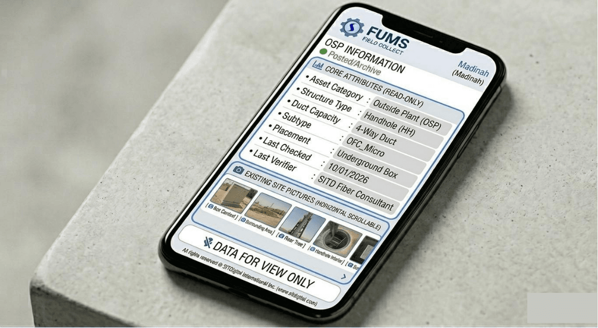
Multi-Utility Naming & Coding Schemas
Full compatibility with standardized asset naming conventions and global codification rules for OSP/ISP data segregation.
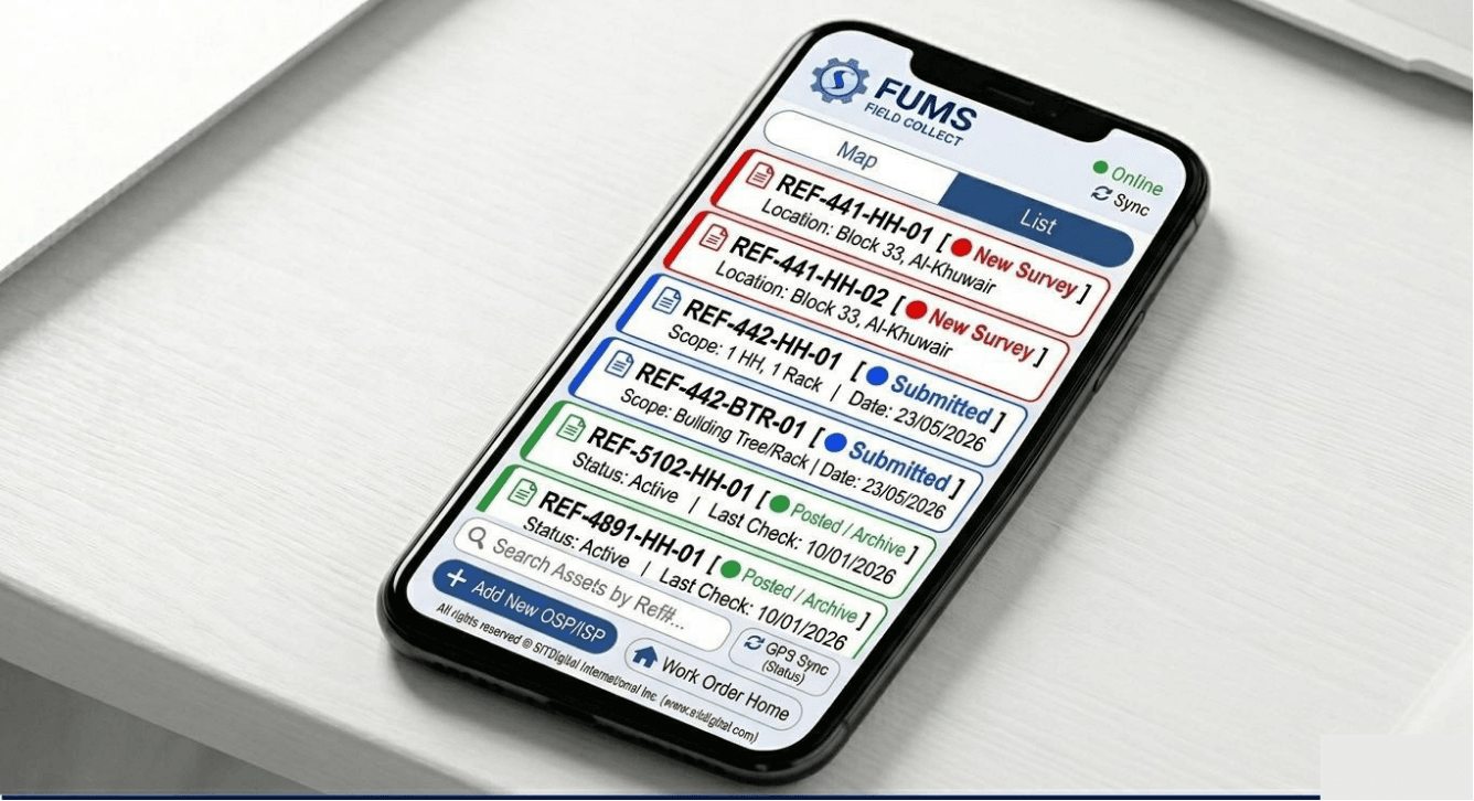
Work Order Management
View and manage assigned work orders with complete details including status, priority, due dates, and progress.
- Project & Task Assignments
- Work Order Tracking
- Status Updates
- Offline/Online Synchronization

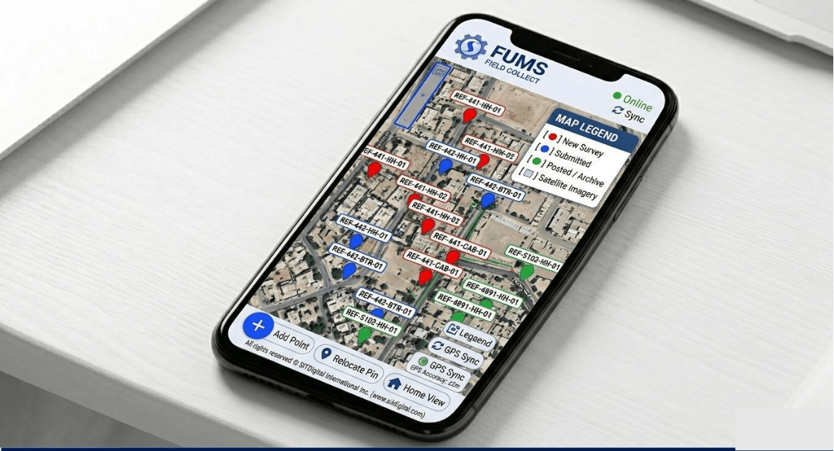
GIS Based Field Survey
Capture asset data with GPS accuracy and visualize information on interactive GIS maps for better field insights.
- GPS-Based Asset Mapping
- Live Location Tracking
- Telecom & Utility Surveys
- Interactive Map Layers
Asset & Site Data Collection
Collect and manage detailed asset information including poles, handholes, cabinets, and fiber assets.
- Pole, Handhole & Cabinet Surveys
- Asset Inventory Management
- Customizable Data Forms
- Support for Multiple Asset Types

QR Code Validation
Scan and validate QR codes on-site to verify assets and ensure accurate inventory records.
- QR Scanning & Validation
- Asset Verification
- Inventory Accuracy
- Reduced Manual Errors
Photo Capture & Evidence Collection
Capture and upload photos as proof of work with timestamps and geo-location information
- Capture Site Photos
- Before/After Documentation
- Geo-Tagged Images
- Improved Quality Assurance

Site Inspection & Validation
Perform on-site inspections and validations using structured forms and digital checklists.
- Custom Inspection Forms
- Quality & Safety Checks
- Field Validation
- Approval Workflow
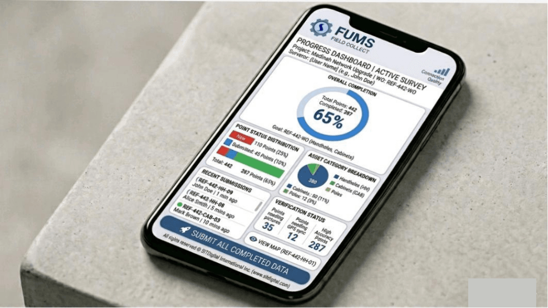
Analytics Dashboard
Monitor field performance, project progress, and team productivity through real-time analytics.
- Real-Time Dashboards
- Survey & Asset Statistics
- Team Performance Metrics
- Data-Driven Insights
Enterprise Interoperability & One-Click Reporting
Instantly compile raw spatial field surveys into clean administrative outputs. Export verified vector datasets directly into CAD, KML, DXF, GeoJSON, CSV, and Revit BIM formats, or generate consolidated Short Jointing Tables and engineering PDFs for instant client approval.